|
China BestBuy Gadget Co., Ltd.
|

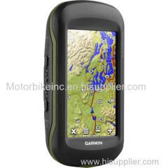
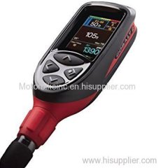
Gar min Oregon 600t GPS Unit
| Payment Terms: | T/T,WU |
| Place of Origin: | Hubei, China (Mainland) |
|
|
|
| Add to My Favorites | |
| HiSupplier Escrow |
Product Detail
Let the GPS capabilities of the Garmin Oregon 600t lead the way on your next outdoor adventure. This handheld navigation device will indicate your cur
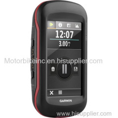
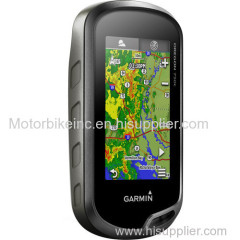
Let the GPS capabilities of the Garmin Oregon 600t lead the way on your next outdoor adventure. This handheld navigation device will indicate your current position and lay digital breadcrumbs showing where you've been. The GPS unit's 3" sunlight-readable touchscreen displays your position in an easy to read manner. You can choose between landscape and portrait modes for the best possible view of the map or data you are trying to interpret. An included topographic map features 100k resolution of physical features. A 3-axis compass is built-in so you will always know your heading. An altimeter lets you know how far you are above sea level, and can help predict weather trends. The unit runs off two AA batteries or the optional rechargeable NiMH pack.
This unit utilizes both GPS and GLONASS satellites for quicker signal acquisition so you get a fix on your position approximately 20 times faster than GPS alone. The receiver also can interpret Wide Area Augmentation System (WAAS) signals so you can receive information from terrestrial antennas even when your view of the sky is obstructed. The WAAS system also provides greater position accuracy overall. Adding to the GPS technologies, this device also features HotFix satellite prediction which uses an algorithm to mimic the movement of the Earth. This technology allows the receiver to quickly regain satellite connection after a couple days of non-use eliminating long initialization times. A worldwide basemap is stored on the unit's internal memory so you will always have an idea of where you are.
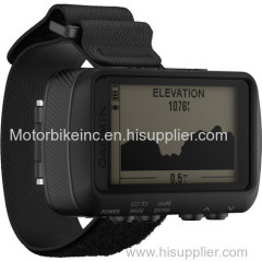
The unit's built-in 3-axis tilt-compensated electronic compass shows your heading even while standing still, no matter how it is positioned. It also houses a barometric altimeter which tracks changes in pressure to pinpoint your precise altitude so you will know your distance from sea level. The included advanced elevation plot software lets you see the entire elevation plot created by your travels and quickly move your zoomed view to any place on the graph. Future plot uses your mapping data to show what to expect on the trail ahead. The altimeter also lets you plot barometric pressure over time which can help you keep an eye on changing weather conditions.
This unit comes preloaded with TOPO U.S. 100K maps. These are contour maps on a scale of 1:100000, and feature metric contour lines. Also included is a worldwide basemap with shaded relief.
The Oregon also features built-in paperless geocaching software, so you can transfer your data to your computer with the supplied USB cord or upload it onto the Web. The internal memory allows you to store up to 4 million unique caches, so you don't have to pick and choose what to upload before your next trip. The unit's screen displays key information, including location, terrain, cache difficulty rating, and hints and descriptions of hiding spots. All of this means no more manually entering coordinates and paper printouts for your geocaching hobby.
You can wirelessly share your data and images using the built-in Bluetooth connectivity. Exchange photos, geocaches, adventures, routes and custom maps between Oregon 600-series devices. Store up to 4000 waypoints on the receiver's built-in memory as well as 10,000 points, 200 saved tracks. A micro SD card slot lets you load TOPO 24K maps for hiking, Trailhead Series TOPO maps for famous trails, BlueChart g2 charts for boating, or City Navigator NT maps data for turn-by-turn routing on roads.
GPS
Utilizes GPS and GLONASS satellites
WAAS-Enabled receiver
HotFix satellite prediction
3-Axis Compass
Barometric altimeter
- Cartography
Preloaded TOPO U.S. 100K maps
Worldwide basemap with shaded relief
Compatible with custom maps
Paperless Geocaching Software
Add your own custom points of interest
4000 waypoint memory
All waypoint data is editable on 1 screen
Micro SD card slot lets you add maps
- Outdoor Features
Hunt/fish calendar
Sun and moon information
Area calculation
Compatible with Garmin Basecamp software
Advanced elevation plot
Tide tables
Picture viewer
Activity tracking calendar
Bluetooth to wirelessly transfer data between units
ANT+ wireless compatible for use with heart rate, cadence, chirp and tempe sensors
- Display
3" sunlight-readable touchscreen display
Reflective display technology uses external light in combination with the device's LED backlight to increase brightness
Choose between portrait to landscape viewing modes
Shortcuts allow you to start tasks with 1 touch
User-selectable profiles
Create custom dashboards with the information you want to see displayed such as elevation or distance traveled
Carabiner Clip
USB / Charging Cable
Limited 1-Year Warranty
UPC: 753759994839
In the Box
Garmin Oregon 600t GPS Unit
Related Search
Find more related products in following catalogs on Hisupplier.com
Company Info
China BestBuy Gadget Co., Ltd. [China (Mainland)]
Business Type:Manufacturer, Trading Company
City: Wuhan
Province/State: Hubei
Country/Region: China (Mainland)